Thursday, March 25, 2010

Who wants to help on a little project?


I just finished reading The Monkey Wrench Gang by Edward Abbey. Short of writing a full review at this time, I'll just say this - it was amazing, and something every nature fan, natural scientist, angered youth or disgruntled conservationist should read. I mean it. I'll even lend out my own copy. Absolutely mandatory read.

On to the plan. No, I do not plan on blowing up the Glen Canyon National Sewage Lagoon Dam. What I'd like to do is grab a few maps of Arizona and of course, Utah; and retrace George Washington Hayduke's journey through the lands. Being somewhat familiar with the country, I did so already while reading the book. I got through most of Southern Utah without a problem, but will need to consult some maps to complete it all.

Anyone else interested?

Wednesday, March 24, 2010

Getting Along With Geologic Time #1 - The Silurian


Graptolite Monograptus tomasii and early plant Baragwanathia longifolia
in Silurian silicics of Australia. Image from Geological Society of Australia.


Welcome to what hopes to be a long list of "Getting Along with Geologic Time" series. The introductory period will, of course, be the Silurian. Why the Silurian first? Why not?

This series of posts will not be (geo)chronological. If it were, it would be no fun. Plus, I know a good quantity of Oneonta Staters that wouldn't log onto this blog for months if they knew the evil, evil Devonian was coming along.

So here we go, Silurian Stylee.

The Beginning

As with all geologic periods, the beginning of the Silurian is characterized by new life after a substantial loss of biotas worldwide. In the case of the Ordovician/Silurian (OS) boundary, there was a mass extinction of 60% of earth's biotas at this time, mainly devastating marine shelf-life. The mass extinction(s) were second in magnitude of deceased marine species, only to pale in comparisson to the horrible events circa 249 MYA. Interestingly, the OS mass extinction is classified by two events, one at approximately 442 MYA another a short 1 MY later. During this time, Gondwanda was drifting into the higher southern latitudes, eventually passing near (possibly completely over) the Southern Pole. This process led to a cooling of the land masses, and likely a global cooling to boot. This cooling, of course, led to extensive glaciation of the Ordivician world. Thus, the world's waters became trapped within extensive ice masses, and sea level dropped. With the corresponding drop in sea level, shallow marine life suffered due to extensive habitat loss. Bryozoans, brachiopods, bivalves and echinoderms suffered the greatest.

The Origins

Silurian refers to a Welsh tribe, the Silures. In 1835, the term "Silurian" was coined by none other than British geologist Roderick Murchison, in a series of events which led to the initial geologic time scales. In a joint paper with fellow Adam Sedgwick, On the Silurian and Cambrian Systems, Exhibiting the order in which the Older Sedimentary Strata Succeed each other in England and Wales; the birth of the geologic time scale, as we know it. Sort of. The partnership of Sedgwick and Murchison would later dissolve over disagreements between the end and beginning of said periods. However, Charles Lapworth later defined a new period in between, the Ordovician, resolving the conflict.

The Epochs

(Europe, North American Equivalent(s))

Llandovery, Alexandrian (443-428 MYA)
Wenlock, Lockportian/Tonawandian (428-422 MYA)
  • Oldest known Tracheophytes appear
Ludlow, Cayugan (422-418 MYA)
Pridoli (418-416 MYA)
  • Named for the town of Pridoli in the Czech Republic, where excellent exposures of the SD (Silurian/Devonian) occur
Paleogeography of the Silurian


Image courtesy Dr. Ron Blakey, Northern Arizona University


As stated earlier, the Silurian geography can be characterized by a slow, southernly drift of supercontinent Gondwanda. Aside from Gondwanda, there were a number of other land masses and cratons drifting towards the equator. These multiple land masses were in the business of colliding around the equator, leading to the Caledonian Orogeny. During this time, land masses of the current New York State, Greendland and Norway were colliding in order to form a second supercontinent, Euramerica.

If you take a look at the image above, generously shared via Wikipedia and UNA's website by Dr. Ron Blakey; you'll notice a massive ocean dominating the northern hemisphere. This ocean, known as Panthalassa, was accompanied by the southern oceans of Proto-Tethy and Paleo-Tethys, which later evolved into, you guessed it; the Tethys Ocean. Also present was the Rheic Ocean, a seaway of the Iapetus.

Paleoclimate of the Silurian

After the Ordivician-Silurian cooling event, the Silurian period experienced a prolonged greenhouse phase. The glaciers which formed with Gondwanda's passing over the South Pole almost disappeared during the Silurian. With the rebound in Ordovician sea levels, the Silurian saw a return to general climate normalcy, in contrast to the erratic conditions of the Cambrian and Ordovician.

Multiple stratas of coquinas (sedimentary rock composed of broken shell fragments) characterize many units of Silurian formations. These conquinas are evident that violent storms were common in the Silurian. Plentiful, violent storms are typical of time periods in which shallow, easily warmed sea surfaces.


End Silurian Mass Extinction Event(s)

The end Silurian extinction, in comparison to others, has been rather neglected in terms of research and understanding. Rumblings has produced trite reasoning such as "probably caused by climate change..." and other vague scenarios.

The widely accepted Lau Event at 420 MYA, the final of three extinction events ending the Silurian; is viewed as a peak in sigma 13 C (blogger does not allow for greek lettering and sub/post scripts) levels. However, the Lau Event, characterized as a massive conodont extinction events, lags behind the disappearance of index fossils by at least one million years. Building upon this event, some paleoclimatologists have theorized another glaciation event as a possible climatic situation contributing to the extinctions.

So what's so great about the Silurian?

So we've reviewed the main concepts of the Silurian. No much ice (lame), a good amount of warm-weather storms (very awesome) and relatively quiet orogenies (Caledonian Range is all we really have to show for it).

What really sticks out about the Silurian is the organisms. The Silurian period is home to the first tracheophytes and land-dwelling vascular plants.
Cooksonia, above, and Baragwanathia, shown in the first image on this page; are some early examples of these early vascular plants. Vascular plants are those which are able to carry food through lignified tissue, and are exclusive to land. Modern examples of vascular plants include ferns, clubmosses, flowering plants, conifers and gymnosperms.

We have the Silurian to thank for these precious lifeforms today.

While the Silurian was an integral time for the plant life of planet Earth, life in this time was dominated by the oceans.

Fishes underwent important changes. The first fish with jaws evolved, and those without jaws diversified.

Some of the first animals to take to land, various centipedes and scorpions, did so during the Silurian.

And there's these:

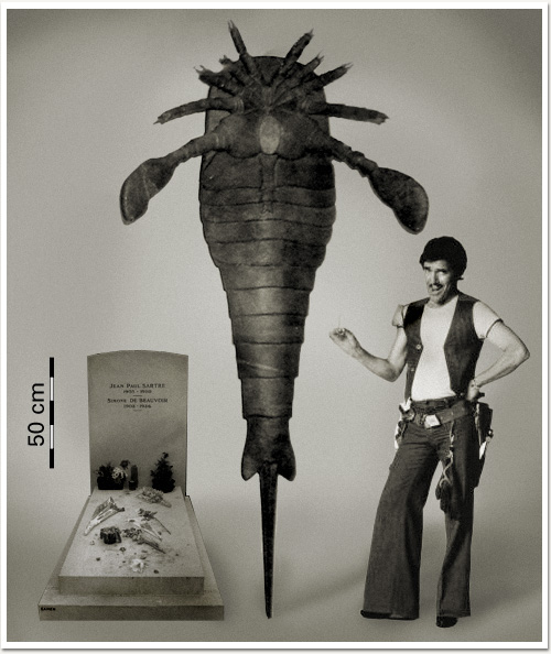
Mixopterus multispinosus

Eurypterids, arthropods of the Chilicerata subphylum; first diversified and became prominent in the Ordivician, but they're just way too cool to not be mentioned. They absolutely ruled Silurian waters (sea water, that is. Eurypterids are expected to have taken to fresh water in the Carboniferous.)

One particular Silurian eurypterid is known as one of the largest arthropods ever know (and by known, of course, we mean fossilized), Pterygotus. Pterygotus was capable of reaching an enourmous 2.3 m (that's about 7', you imperialists.) However, as is so common in the fossil record, biggest is certainly not the best. Pterygotus died out by the middle Devonian. Four species of Pterygotus existed, with P. anglicus being the type species. The genus was first described by none other than the legendary Louis Agassiz in 1839. (Go Switzerland!)

And, for a little joke:
Did you know elephants diversified in the Silurian? Neither did I!

Stay tuned for more Getting Along with Geologic Time.

Sources:

Don't be completely discouraged by Wikipedia. Most of the time, the articles are written by legitimate scientists with proper sources. I always check the sources before using the information.

The Paleontology Portal

Wikipedia - The Silurian

Wikipedia - Vascular Plants


Go baseflow go!

Due to the current state of the economy and the current job, I do not have the funds or time to conduct elaborate experiments at the time being. So for now, try to enjoy a series of extremely amateur mini experiments!

I was reading the paper the other day and saw an article stating there was a possibility of some flooding. I was able to scrap up some petty cash (no joke) and purchased a cheap rain gauge. I was able to rig it up to the door of the dog cage in my backyard like so:


After returning 24 hours later, it yielded ~4.4cm of rainfall for the previous night.


The opening to the gauge has a total 2.54cm(sq) surface area for a total of 4.4cm of rainfall per 2.54cm of surface area. This amount of rainfall for a 24 hour window in a much larger space plus baseflow from higher elevations and still melting snow would definitely cause some amounts of flooding....alike so:


Tuesday, March 23, 2010

Things to get Downright Fluvial About

After a few days, I went through the videos of the drainage experiments, and here they are:
**As of 3/23/2010 17:18, Two of the three videos have not yet been processed by YouTube. Please be patient, they'll be up soon.

#1 - Quick Mass Movement


#2 - Mass Movement and Damming


#3 - Earth Dam Break + Knickpoint Migration


I left out the best part. I ripped some leaves away from around a groundwater seep and watched a beautiful drainage pattern form. However, as soon as I calmed down from the beauty of it all, I clicked the camera on to get a blinking battery icon.

These things happen. I was able to snap a good amount of photographs of it though, and they should be up within a few days.

Also, look forward to this blog linking up with my flickr account within the next few days.

Sunday, March 21, 2010

The New Directions of Water and Rocks


Since my return from the NE/SE GSA conference this past week, it has been increasingly difficult to rage on over topics typical of this blog. I wanted to take this blog slow, waiting until a solid faction of followers was present, and grow like like to CO2 levels in our atmosphere (zing!). This hasn't been the case. Debuting in May 2009, Water n Rocks has only totaled 4 followers. Two of which are authors of this blog, and two are emotionally involved with authors.

It isn't about the followers, and due to adding Water and Rocks to Facebook traffic has been on the rise. Mostly from a small mountain town in Southern NY, and some image searches which have led viewers here ("People write about rocks and water?!").

Needless to say, this blog is not a diary. I started it in order to open peoples eyes to the wonders of out natural world. Yes, with emphasis on geology, geomorphology and hydroscience; but still as a source of pictures for people who just want to discover new natural phenomena in their own backyard.

It was quite embarrassing on the art of this blog to be outright rejected by a very populat blogroll, Nature Blog Network. I will not link to this site as I do not wish to start a word war with these folks, rather I just want to pass on this new life anecdote I have learned from this experience.

Don't take anything too seriously. I was pretty upset with the rejection. "We feel your blog does not match our interests...(paraphrased)" was downright insulting at the moment I read the terse email. Why would a blogroll intended to bring people into their community reject someone searching for a community to belong to? It doesn't make much sense. But this is not the point of this post. The point of this post is more of a State of the Blog address.

So without further adieu, here is what you have to expect in the next epoch (see what I did there?) or Water and Rocks...at the Same Time.

Field Research

I am currently conducting makeshift experiments in first-order drainages in hope of finding insight into catastrophic flooding - think Lake Missoula floods, the "biblical" flood, etc. This is more intended for educational purposes rather than hard science. Quick and Dirty, if you will.

Textbook Diving

Anyone who knows how I function can recall and excessive amount of textbooks, from amazing to awful; on a bowed down shelf in my room. From time to time I will be diving into these textbooks, finding diagrams and visual aides to help clarify geologic and hydrologic concepts - both quantitative and qualitatively.

Pictures!

The photos from the Western Trip of 2009 do exist, I swear. I was doing a photoblog type presentation of this trip, and may continue to, but not in the frequency I was. I burned myself out with massive posts on locations. Trying to fit a week of the Grand Canyon into one post is...well, impossible.

Philosophy

Just kidding. I do not believe in philosophy (dodges poorly thrown bricks). Instead, I plan to question whatever I feel like, from other scientists' research to my own (clay varves in CNY?! Bullshit!)

Themed, Seriesed Posts

And making up new words, like seriesed. Along with the textbook dives, I also plan on multiple types of posts with a common title or theme. One of which will be glimpses into geologic history. Most common, I will go back to the Plesitocene and Siluirian. Because they're awweeesommmme. Deal with it.
And more. I don't know what, yet, but be ready for anything. Also, I am looking to start a new blog in which the ONLY topic will be geology, hydrology and biological field trips (this includes paleo-goodies).

And as always, please comment, leave positive and negative feedback, and if you are interfested in becoming an author at this blog, please let me know.

Wednesday, March 17, 2010

Who knows where ideas come from. They just appear.


Time to think about whatever for the first time in almost a week.

The rain killed all the snow, so the field season is back and full of piss and vinegar.

I exhumed the bookface after years of dormancy. Three years dead. Science is a hell of a drug.

I played in a first order drainage for two hours today. I diverted flow. I built dams out of clay, pebbles/cobbled and debris. I watched sediment bars build, surface, drown, erode and grow up to be sediment is another bar downstream.

I took videos of a bank collapse, bar formation and upwelling.

Three packages came in the mail. Oh, happy day.

A bill came in the mail for loans. Oh, terrible day. (It's okay, they'll be dormant again for two years.

Bookface has transformed into a terrifying ad machine.

I'm still waiting on my Buffalo email account, to detach myself (slightly) from the substance abuse capital of college, Oneonta State.*

According to a talk at GSA by Callan Bently of Mountain Beltway, GeoBlogging is on the rise. Maybe I'll shout at him to check out this site and the winners over at Second Floor Science. Good kids over there.

Something you may not hear so much: How can I delete friends from bookface?

I have a dream. That dream is to build a house. Within this house, a staircase. Within this staircase, in ascending order, slabs of the Grand Staircase.

I can ride my bike with no handelbars, no handlebars, no handlebars.

I have so much to do with my life. I just want to play in water.

Dear Baltimore, you embarrassed yourself with your so-called Buffalo Chicken sandwich. Stick to blue crab and lake trout.

This is the most amazing graph of water usage I have ever seen. During the USA/Canada gold medal hockey match:

I have another new blog idea. Geology field trips only. I would be looking for multiple contributors, world wide.

*Disclaimer: Most of the students at Oneonta State are good human beings. Some casually drink and know how to control themselves. Others, not so much.

Thursday, March 11, 2010

Huh?..Wha?...Oh. Hello Spring.


Like bears waking from hibernation, us non-glacial geologists awake from the winter coma ready for some hot, outdoorsy geology action. I personally am looking forward to locating and dusting off all the research gear and heading out into some remote creek or stream but any geologic expedition would not be overlooked. Keep checking in on any fun and wacky adventures we all get into this spring and summer!

Monday, February 22, 2010

Oh, The Colors!


Looks like some nasty precipiation heading this way. I love watching storms like this slowly work their way west from Buffalo/Great Lakes to eventually lose power and totally disappoint me when they get to central NY...

Saturday, February 20, 2010

A Break in the Nothingness of Water n Rocks'... winter

So in case you couldn't tell, I got into UB. I received a digital acceptance last week, but the final hard copy came in the mail today.

This is my second acceptance letter I've received overall (two out of three aint bad!) and both have come in a small envelope. This scared me originally in my Oneonta acceptance, as I was led to believe (via movies and such) that acceptance came in big beautiful 9"x11" manilla packets, or in boxes with hats, scarves and whatever college-labeled flair they can recruit you with. It's become obvious that either A) I'm just not that great a candidate, but just good enough to get in or; B) even colleges are cutting back on recruiting or persuasive techniques.

Anyways, I'll be in Buffalo this fall, unfortunately, without a project at this point. I got in on MA rather than MS basis, which isn't what I wanted, but will do for now. My plan is to get into an MS by semester #3, if not, I'll do the research my damned self. I've done it before.

_______________________________________________________

I've also extended an invitation to Joey from Oneonta/Port Jervis, NY to contribute to the blog. "Rock Doctor Aucoin" has created his own series of websites and such, so it seems like he's out for the time being. Tony is still here and looking for that magical glacier.

_______________________________________________________

My plans until grad school in August right now are jumbled. I'd love to get to GSA NE/SE in Baltimore, but right now it seems unlikely. I might start planning some summer camping/geology trips this summer, before asshole decides to shut down every park in the State. If this really goes through, I might spend my summer defended New Yorker's rights to access our beautiful land.

_______________________________________________________

Thursday, December 31, 2009

Winter Hiatus


Not much to do in the winter in CNY in terms of geology, so I'll be taking a break for a while. Based on Tony's amount of posts lately, he will be to.

Wednesday, November 18, 2009

Since No One Reads This


Direct Quote from Co-Author Tony Grimes:

"I'd have a fluvigasm."

Tuesday, November 17, 2009

Water without Rocks


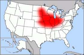
The USGS is reporting (or was, on November 9th) that the amount of pesticides has decreased in the waters of America's "Corn Belt". For those of you unaware, the Corn Belt is an agriculturally dominated region of the Middle United States, centered mainly over Iowa, Missouri, Illinois, Indiana and Ohio.

The USGS study states that pesticide levels have dropped over the decade-long period from 1996 to 2006. This is a direct result of fewer applications, mandated by the EPA, to corn plots throughout the region.

Pesticides which were accounted for were mostly herbicides applied to corn and soybean farmland in order to control weed growth. In total, eleven chemicals were monitored, including acetochlor, cyanazine, metolachlor. Though most levels declined due to enforced reductions in applications, S-metochlor was introduced, which was stronger in concentration than it's predecessor, thus reducing the amount in rivers.

How does "solid" geology work into it all? Skip Vecchia has the answer:

“The steeper decline in these instances (EDIT: atrazine and metolachlor) may be caused by agricultural management practices that have reduced pesticide transport, but data on management practices are not adequate to definitively answer the question. Overall, use is the most dominant factor driving changes in concentrations.”

However, not all pesticide concentrations decreased over the time. Simizine, a pesticide which can also be used domestically, as well as along roadsides by transportation departments, rose more sharply than the usage trends would suggest.

Rivers surveyed were included within the Upper Mississippi, Ohio and Missouri watersheds.

Source:
Pesticide Levels Decline in Corn Belt Rivers. Bob Gilliam, USGS.

You can take a look for yourselves at the following websites:
USGS Newsroom: Pesticide Levels Decrease in Corn Belt Rivers

Friday, October 30, 2009

An interesting find

I found myself driving up the road past my mother's house and I spotted an unique outcrop at a local swimming hole. Even though I had driven and run past this outcrop many, many times, I just noticed it for the first time as a geologist. It is possible it was exposed from hillside runoff during a flood event that occurred in 2006. Take a look.


As you can see, the exposed rock to the left of the picture is tilting back into the hillside while the rock to the right is still positioned horizontal. The distance between the two exposed outcrop is a matter of a meter or two. Here's a closer look:


Unfortunately, the outcrop itself is pretty inaccessible. Recent rain events have flooded the river to the point where crossing it will be risky and the top of the ridge is private property used for hunting. This is definitely on my list of outcrops to check out.

Wednesday, October 7, 2009

Phytoplankton for everyone!

I found this pretty cool article on geology.com and it reminded me of a Dan Brown book I read awhile back. If you like science like I do, then you'll be able to focus more on the "what ifs" about the book than the writing. Deception Point turns out to be pretty neat-o if you're interested in sciences.

Tuesday, September 29, 2009

8.0 Earthquake near Samoa


A heads up to GeoTripper for pointing this out earlier today. A magnitude 8.0 earthquake rocked the region around American Samoa today, with an epicenter just 135 miles from mainland Samoa.

Originally, tsunami warnings were issued as far away as Hawaii. NOAA has since canceled these warnings, as Pago Pago, located in Samoa, only experienced waves with a maximum amplitude of 1.57m and a period (frequency) of 4 minutes. (Source, NOAA)

The Tonga Trench, located just west of the earthquake center, has been a very active tectonic region - with the Pacific Plate moving underneath the Australian Plate at a rate of 86 mm/year. Currently, the USGS believes that a normal fault occurred here, near the outer rise of the Pacific Plate. (Source, USGS)

If you want to check out the location of the quake, drop the coordinates "15.558°S, 172.073°W" into Google Earth and check out the proximity to Pago Pago and Samoa, as well as the beautiful images of the trench just to the west of the epicenter. No wonder there was a seismic event here.

Update: Tsunamis were reported in Pago Pago, contrary to the data I received from NOAA. According to CNN, a 3m tsunami hit just after the earthquake.