Not much to do in the winter in CNY in terms of geology, so I'll be taking a break for a while. Based on Tony's amount of posts lately, he will be to.
Thursday, December 31, 2009
Winter Hiatus
Not much to do in the winter in CNY in terms of geology, so I'll be taking a break for a while. Based on Tony's amount of posts lately, he will be to.
Wednesday, November 18, 2009

Tuesday, November 17, 2009
Water without Rocks
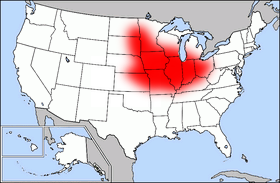
The USGS is reporting (or was, on November 9th) that the amount of pesticides has decreased in the waters of America's "Corn Belt". For those of you unaware, the Corn Belt is an agriculturally dominated region of the Middle United States, centered mainly over Iowa, Missouri, Illinois, Indiana and Ohio.
The USGS study states that pesticide levels have dropped over the decade-long period from 1996 to 2006. This is a direct result of fewer applications, mandated by the EPA, to corn plots throughout the region.
Pesticides which were accounted for were mostly herbicides applied to corn and soybean farmland in order to control weed growth. In total, eleven chemicals were monitored, including acetochlor, cyanazine, metolachlor. Though most levels declined due to enforced reductions in applications, S-metochlor was introduced, which was stronger in concentration than it's predecessor, thus reducing the amount in rivers.
How does "solid" geology work into it all? Skip Vecchia has the answer:
“The steeper decline in these instances (EDIT: atrazine and metolachlor) may be caused by agricultural management practices that have reduced pesticide transport, but data on management practices are not adequate to definitively answer the question. Overall, use is the most dominant factor driving changes in concentrations.”
However, not all pesticide concentrations decreased over the time. Simizine, a pesticide which can also be used domestically, as well as along roadsides by transportation departments, rose more sharply than the usage trends would suggest.
Rivers surveyed were included within the Upper Mississippi, Ohio and Missouri watersheds.
Source: Pesticide Levels Decline in Corn Belt Rivers. Bob Gilliam, USGS.
You can take a look for yourselves at the following websites:
USGS Newsroom: Pesticide Levels Decrease in Corn Belt Rivers
Friday, October 30, 2009
An interesting find
I found myself driving up the road past my mother's house and I spotted an unique outcrop at a local swimming hole. Even though I had driven and run past this outcrop many, many times, I just noticed it for the first time as a geologist. It is possible it was exposed from hillside runoff during a flood event that occurred in 2006. Take a look.


As you can see, the exposed rock to the left of the picture is tilting back into the hillside while the rock to the right is still positioned horizontal. The distance between the two exposed outcrop is a matter of a meter or two. Here's a closer look:


Unfortunately, the outcrop itself is pretty inaccessible. Recent rain events have flooded the river to the point where crossing it will be risky and the top of the ridge is private property used for hunting. This is definitely on my list of outcrops to check out.
Wednesday, October 7, 2009
Phytoplankton for everyone!
I found this pretty cool article on geology.com and it reminded me of a Dan Brown book I read awhile back. If you like science like I do, then you'll be able to focus more on the "what ifs" about the book than the writing. Deception Point turns out to be pretty neat-o if you're interested in sciences.
Tuesday, September 29, 2009
8.0 Earthquake near Samoa

A heads up to GeoTripper for pointing this out earlier today. A magnitude 8.0 earthquake rocked the region around American Samoa today, with an epicenter just 135 miles from mainland Samoa.
Originally, tsunami warnings were issued as far away as Hawaii. NOAA has since canceled these warnings, as Pago Pago, located in Samoa, only experienced waves with a maximum amplitude of 1.57m and a period (frequency) of 4 minutes. (Source, NOAA)
The Tonga Trench, located just west of the earthquake center, has been a very active tectonic region - with the Pacific Plate moving underneath the Australian Plate at a rate of 86 mm/year. Currently, the USGS believes that a normal fault occurred here, near the outer rise of the Pacific Plate. (Source, USGS)
If you want to check out the location of the quake, drop the coordinates "15.558°S, 172.073°W" into Google Earth and check out the proximity to Pago Pago and Samoa, as well as the beautiful images of the trench just to the west of the epicenter. No wonder there was a seismic event here.
Update: Tsunamis were reported in Pago Pago, contrary to the data I received from NOAA. According to CNN, a 3m tsunami hit just after the earthquake.
Saturday, September 26, 2009

Thursday, September 24, 2009
Marcellus Shale and you
As most "geology knowledged" people know, the Northeast United States is sitting on top of billions of gallons of oil in the Marcellus Shale formation. Being from and living in upstate New York, I am not immune to all the hulabaloo surrounding it. I see signs for rallies and meetings everywhere.
It is nice to see that several people have taken the initiative to form these groups and organizations to inform the public of the details of oil drilling. I was even asked by an acquaintance to set up a meeting with the professor of all geology professors, Dr. James Ebert, in an attempt to better understand the geologic side of the issue (although his group would be run better if he knew how to turn on a computer).
You stay classy, internetz.
Another Strike Against Global Climate Change

I like severe weather. Studying radar maps and seeing bigger storms year after year. I like when the summer gets hotter than normal, and winter days drop into the negatives. That kind of global climate change, I must say, excited me.
However, I don't like bitter beer.
Researches in the Czeck Hydrometeorological Institute have concluded the quality of Saaz hops, a mild variety used in pilsner such as Pilsner Urquell, has decreased over the last fifty years. This decrease in quality (attributed to lower Alpha Acid percentage and lower yields) has led to a bitter brew, and decreasing yields.
The articles can be viewed here:
Czech Meteorological Institute: Climate Change Depresses Beer Drinkers
Edible Geography: The Taste of Climate Change
In case you were wondering: The image above, courtesy of Wikipedia, is a map of the Czech Republic. In beer caps.
Wednesday, September 23, 2009
Random Geology Photo #001
 The first installment of Random Geology Photo comes to us from The Garden of the Gods outside of Colorado Springs, Colorado. This beautiful, almost 90 degree rotated bedrock plane was titled "on end" during the Rocky Mountain Orogenies, though I cannot guess as to which one as of right now.
This wonderful red-orange rock, and pink in certain light, is mostly Triassic sandstone, with various sedimentary structures such as ripple marks. There is also pebble-pavements present, (as well as a little aliteration) which may not be attributed as a common sedimentary structure, but I for one believe it should considered.
Monday, September 21, 2009
Ice Core Delight
I was surfing geology.com about a month ago when I came across this article published by the National Geographic and subsequently posted on geology.com.
For those of you who are unfamiliar or inexperienced in glaciology, I posted a video interview with Penn State glaciologist Richard Alley to help you learn a little bit more about the science and history behind glaciers plus some impacts of glacial melting.
Enjoy!
For those of you who are unfamiliar or inexperienced in glaciology, I posted a video interview with Penn State glaciologist Richard Alley to help you learn a little bit more about the science and history behind glaciers plus some impacts of glacial melting.
Enjoy!

Sunday, September 20, 2009
Back to Reality

First off, let's welcome Tony to Water and Rocks... The wait was long overdue, I've been waiting for someone to post with for a while now.
A little update: Today was my last day of work at Historic Sylvan Beach Amusement Park, so posting should become more common now. This winter I plan on some pseudo-research, as it becomes rather difficult to study geology under six feet of snow on the Tug Hill Plateau. I plan on heading back up to Salmon River Falls a few more times, as well as a little bit of deer-trail observations, but that will probably be over at Into The Woods.
Check back soon.
Greetings

Hello all. Roy-z was kind enough to invite me to post on his blog and I decided to start off with telling ya'll a little about me. I was born and raise in Otego New York and attended Unatego Jr/Sr high. I recently graduated with Roy from Oneonta State with a degree in Geology. My area of interest focuses on fluvial geomorphology as well as sedimentology and stratigraphy. Prior to graduating, I was involved in researching the movement of sediment particles in stream settings. Unfortunalty, I left the project uncompleted when I graduated and I would like to continue sometime in the future.
I also have a great respect for nature and all its "happenings." I often sit and wonder how many of Earth's processes work. I hope that in the future that I will obtain a better understanding of the workings of our planet.
Until next time.
Thursday, September 17, 2009
New Laptop Plug
So it seems Water and Rocks...At The Same Time might be back up and running respectably again. It's only been about 2 months (is that too long) of computer failures, work, GRE studying and other non-geology, mostly canine-related time consumption. However, thanks to my new, fancy, computin' machine, it looks like the future can be restored (did that blow your mind?!).
Anyways, time to plug the new laptop. Thanks to a sick deal at Best Buy, I got myself a new Gateway NV-52 for a cool $560. Most comparable notebooks, such as the Dell Inspiron 15 and various HP abominations, would run roughly $630.
Specs: Vista 64-Bit and Windows 7 upgrade, 4GB of sheep, and a cool 320GB (advertised) hard drive. I think it's a sick deal.
Sunday, September 6, 2009
Let's Get Back Into It
So, computer problems aside, and no real replacement laptop available yet, I've decided to maintain writing about our wonderful environment and the ground we walk on, without the use of question marks, sound, and the final letter of the alphabet.
During my browsing yesterday, just an hour before work, but interesting enough to cause me to be slightly later than normal, I ran across a link on EPOD (which, by the way, has a pretty new layout) for geography-based maps. Now the subject would cause most to be bored to tears by the simple concept of maps of demographics, income, computer usage, this website, World Mapper, has all kinds of maps, including geologic disasters, natural resources, fuel usage, and many other earth-science, meteorological and hydro-based goodies. I encourage everyone to go check it out.
Western Update: I'll be posting again soon, as the Amusement Park will only be opened Friday-Saturday-Sunday after Labor Day. So no fear! Pictures of sunsets, cliffs, deadly trails, rockfalls and occasional (tamed) Grand Canyon wildlife are on their way.
Wednesday, July 15, 2009
FAIL

My Toshiba has recently developed a nasty sickness and may not survive the night. INcluded on my baby were the pictures from this summers Colorado-Arizona-Utah trip. The fact of it all is that those picture may never be seen again. Best case scenario my harddrive is still salvagable and we'll be back up and running in no time. Likely scenario: all is lost.
Thursday, July 2, 2009
Colorado Springs - Mesa Verde

...is pretty much just a westward trek through the Rockies in southern Colorado. Now, before you hardcore Rockies enthusiasts come at me for that last statement, mind you: we were just passing through at this point on our way to Mesa Verde National Park. If it were up to me, I would have checked out the Tepee Buttes, Spanish peaks, anything and everything between Colorado City and Durango - but it wasn't up to me.
BUT - we stopped by Great Sand Dunes National Park.
I enjoyed Sand Dunes. We actually skipped a stop further in towards Silverton, Colorado, a town built within an ancient caldera to go there. Now, we ended up skipping a few spots on this trip, and I don't know who's to blame for this, so I'll let it go. But please, never tell a group of geologist that they're going to a caldera - and not do it.
On to Sand Dunes. Sadly, we did not spend an ample amount of time here either, but what we did see was what gets geomorphologists like myself to sleep at night.
The first photo on the top of the page, is being described in the lecture of the century by Dr. Albanese here (heavy, dark minerals [magnetite] are being deposited in the shallow stream, due to their higher density, they form bars). I figured that this was about as good as a geology lecture photo gets, so here it is:

What are, I believe, some SUCO field trip goers:
 Some serious cumulnimbi forming north of the Dunes:
 Wishing to grow up to be just like the Navajo Sandstone:
And later that day...
We also drove over the continental divide, did some nalgene experiments (to no avail) and had a beautiful overlook of the San Juan National Forest later on. At this point, though, we had driven into more storms associated with the thunderheads in picture #4, so photography increased in difficulty.
The Continental Divide (someone put a sign in front of it...):

A good looking jay at the San Juan N.F. overlook...you might even say, Stellar:

And one amazing view of the SJNF:


Tuesday, June 30, 2009
Garden of the Gods: Mainly a Picture Show
 (Still) Day 4 - Garden of the Gods, Colorado Springs, Colorado
After our morning of tempting gravity to pull our 2-ton vans down 5000' of Pike's Peak Granite, we venture on to western Colorado Springs to unwind with cold nalgenes and soft rock. Colorado BASIN soft rock (ohhh geology joke....) Anyways, we arrive at Garden of the Gods around 1PM, after eating lunch in the scalding visitor's center parking lot, and after visiting the welcoming center. (Beware: this is not the first time we'll stop by a visitor's center before actually visiting the attraction.)
The Garen of the Gods stop is a series of tremendous, near vertical or completely vertical tipping bedrock monoliths protruding upwards. Aside from one bright white limestone piece, many orange and deep pinkish-tan sandstone outcrops (with outrageous sedimentary structures) surround you as you enter the park. I believe the rocks are Paleozoic, but my rite-in-the-rain notebook is currently drying in the dining room right now. Anyways, on to more pitcures.
Les Hasbargen in Super-Geologist-Photo Mode
 Vertical Bedrock=Drool
 Sedimentary Structures worth Killing For
 Something happened riiiiiight here...
 Don't tell my geo-colleagues I took pictures of a dicot...I mean plant..
 And this.
Monday, June 29, 2009
Pikes Peak (or) I'm Going to Die, Volume 1
Day 4
Pikes Peak, Colorado
So we got up pretty early to take a ride up to Pikes Peak. Thinking that it would be a typical up-mountain tredge in our beastly Chevy 3500 Vans, and obviously tainted by my assumption that this meager 14,000' peak would be just like negotiating Whiteface Mountain (4600') of the Adirondacks.
I was wrong.
The ride up was devastating. Switchbacks all the way up, for about 14 miles I believe, all with near-vertical cliffs at every hairpin turn. Not to mention, coming around every corner there seemed to be rock outcroppings just high enough to obscure the view from the vans. Also, it doesn't help when your driver is a rubber-necking geology professor more interested in the surrounding mountains than his own well-being.
Our first stop was at a visitor's center about 30% up the mountain by a nice body of water known as Crystal Creek Reservoir.

A little later we stopped once again, a stop which was probably induced by personal comfort issues (gasses expand at higher altitudes, including the ones inside you) at Glen Cove. From here you can see a heavily jointed rock face, as to be expected in this part of the country, but also, what seems suspiciously like a rock glacier...

To see the magical rock glacier, look in between the trees in the center of the photograph. I have not found any published information on rock glaciers at Pikes Peak, but it's still kind of a new field. This looks quite a bit like those developed in the highlands of Maine which remain active in movement during the summer months when temperatures can fall below freezing.
Moving on. On to the Peak itself! From here you'll see a few typecast tourist-rockhound photos. But they're still rad, so check them out.

Looking out over Colorado Springs vicinity.

Some much tougher grasses than myself...

A hungry fox...

Rockhounding some Pike's Peak Granite

Scientists at play...

...and water and rocks, at the same time...
Coming up next: Day 4 Part 2 - Garden of the Gods
Sunday, June 28, 2009
Getting it Started Again
So it's been about two weeks since we returned from the Western trip, and I figure it's about time to start posting again. I plan on doing a day-by-day kind of this, but for the sake of boredom I will sum up the first three travel days into one post, rather than three.
Day 1 - Oneonta-Enon Beach, Ohio
Upon arriving at our (meth lab) campsite in Enon beach, Ohio, camp spirits are high. Everyone is getting to know each other, though the vans were semi-segregated so far (geology in one van, bio-ecology in the other, including professors.) We decided to time our tent-setting-up, but gave up after 10 minutes (we got better after this one day, we just forgot how to be decent human beings for one day).
Like I said, camp spirits are high, at least until dinner shows up...
TUNA SURPRISE!
Meanwhile, Ross, Brenden and Ryan are out getting a 30 rack of Miller High Life...
SPIRITS RETURN TO HIGH!
And Ducks:

Day 2 - Enon Beach, Ohio - Clinton Lake, Kansas
Definitely an improvement on the previous campsite. The drive was truly awful, sitting 3-a-seat from 7am-4pm, but camp spirits remain in good form, and the campsite is actually really nice. There is a reservoir nearby, and the pseudo-sunset offered some good dusk photography. Not much else to report, however, so here's some more pictures yayyy...
A common Bluet...though not blue at all:

A nice dusk shot of a bass condominium:

Day 3 - Clinton Lake, Kansas - Colorado Springs, Obvious (Getting Close!)
The excitement grows as we enter the Great(er) Plains of North America and venture into the territory of Pronghorn and Mule Deer. It's a welcome sight fore sore eyes of plains cottonwood leaves and a few insects.
Once we arrive in the greater Colorado Springs area, everything changes. Mountains rise up again, and us New Yorkers find solace in the fact there there's still snow atop Pike's Peak (just kidding..,or am I.) Also, it's taco night, and I'm cooking!

Next Up: Pike's Peak, Garden of the Gods
Sunday, May 24, 2009
Places to Be

Water n Rocks will be on hiatus for about three weeks as the authors will be taking a trip to the Southern Rocky Mountains.
Here's the itinerary:
May
25 - Depart Oneonta at 7 AM, Camping in Ohio
26 - Travel Day, camping in Kansas (or Nebraska)
27 - Arrive and Camp in Colorado Springs, CO at Chatfield State Park
28 - Pike's Peak, Garden of the Gods, Chatfield St. Pk.
29 - Petrified Forest, Morefield, Arizona
30 - Mesa Verde Nat'l Park, Balcony House, Morefield Arizona
31 - Silverton, CO, Camp at Morefield, Arizona
June
1 - Grand Canyon - Mather Campground
2 - Grand Canyon, West Rim - Mather Campground
3 - Grand Canyon, Cedar Ridge - Mather Campground
4 - Grand Canyon, East Rim - Mather Campground
5 - Travel Day, Zion National Park
6 - Hiking in Zion
7 - Arches National Park, Moab, Utah
8 - Arches National Park, Moab, Utah
9 - Mt. Evans, CO, Chatfield St. Pk.
10 - Rocky Mountain Nat'l Park, CO, Chatfield St. Pk.
11 - Arsenal Wilfdlife Refuge, Dinosaur Ridge, Red Rocks, Chatfiels St. Pk.
12 - Ogallala Aquifer, Nebraska
13 - Travel, Iowa
14 - Travel, Ohio
15 - Return to Oneonta, NY
Wednesday, May 20, 2009
The Water and Rocks...At The Same Time Phenotype
Today I headed up to Salmon River Falls in the Orwell(ish) area of Oswego County, New York. The falls had been an important fishing location for local Iroqouis natives before the settlement of the white men in central New York. Although, you wouldn't know it up in this area - there's hardly anyone here.
Recently the NY DEC has thrown some cash at the Salmon River Falls, and since it is situated on state land, they have built small trails and wooden stairs down to the top of the falls themsleves.
The falls are etched into 440+ MYA sandstones (that's Ordivician for non-geologers) and rise over 100' above the lower riverbed. The beds are mostly planar, with many ripple marks on the top layers, which are heavily jointed.
I appologise for the brief geology session, but this was more of a reconaissance mission than an in-depth study. However, if you're curious as to the formation of the falls - so am I. The river system, not a very powerful one, cuts deep into the sandstone without much explanation. My guess is that this was formed subglacially, mainly due to my previous studies on tunnel valleys along with the presence of striations and potholes, but I've truly never seen anything produce a channel quite like this one.
Now for pictures!
 With my girl Lily atop the Falls.
 The Salmon River leading towards the Falls.
 Some glacially "punk'd" asymmetrical ripples.
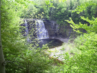 The Falls themselves.
 ...And cliffs on the northside of the channel.
Monday, May 18, 2009
5-17 Circumzenithal Arc
Always look at the sky.
If you're ever searching for something to catch your interest, or something rare to shoot, always know that the sky is always worth taking a glance at. In the middle of a "graduation" party just yesterday, I decided to take a glance at the sky, around 3:45 PM Eastern. What I saw was this:
 The sky has been my best friend these past months where it has been hard trying to get out into the woods and explore. This is the second arc I've seen in the skies above my house in the past year - the first being on a completely clear day in June of last summer.
So my advise to everyone boils down to one thing: If you can't see anything in front of you, look up.
Update: I decided to add a few more shots to the post. Enjoy.

This on kind of offers a matchstick ignition illusion to the red pine tree without a top in the lower right.
 Peaking out from behind clouds.
Subscribe to:
Posts (Atom)


