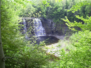
Recently the NY DEC has thrown some cash at the Salmon River Falls, and since it is situated on state land, they have built small trails and wooden stairs down to the top of the falls themsleves.
The falls are etched into 440+ MYA sandstones (that's Ordivician for non-geologers) and rise over 100' above the lower riverbed. The beds are mostly planar, with many ripple marks on the top layers, which are heavily jointed.
I appologise for the brief geology session, but this was more of a reconaissance mission than an in-depth study. However, if you're curious as to the formation of the falls - so am I. The river system, not a very powerful one, cuts deep into the sandstone without much explanation. My guess is that this was formed subglacially, mainly due to my previous studies on tunnel valleys along with the presence of striations and potholes, but I've truly never seen anything produce a channel quite like this one.
Now for pictures!
 With my girl Lily atop the Falls.
 The Salmon River leading towards the Falls.
 Some glacially "punk'd" asymmetrical ripples.
 The Falls themselves.
 ...And cliffs on the northside of the channel.


No comments:
Post a Comment