Showing posts with label Water. Show all posts

Thursday, April 22, 2010

They're not Seahorses, They're Eurypterids

With the coming of a new season, one which does not bury the Central New York strata in many feet of snow, is the gradual opening of an unofficial hunting season.

The snow disappears, some glaring ball of fire in the sky once again shows it's face. The ground dries out and pack boots are not required for simple tasks such as walking dogs or getting the mail.

Colorful birds show up or molt from earth toned ones, singing the hunter into the woods as he finally - after months of researching, planning, readying the weapons and of course - dreaming of the kill.

This time has approached in central New York. The season is open.

It's time to hunt some fossils.

ON Tuesday earlier on this week, fellow dead-animals-in-rock enthusiast Randall and myself decided to meet up in Mohawk, NY to start a journey through the Silurian and Devonian boundary rocks of New York's Mohawk Valley. Stops were planned in a total of three counties (Herkimer, Oneida and Madison) known for sedimentary rocks of the middle Paleozoic seas.

Starting near Mohawk, NY; our first stop were Dayville Member carbonates...which are pretty much in the middle of nowhere, near the town of Getman Corners.
On top you can see some the much more planar-bedded Dayville. Member. We're still in the (upper) Devonian at this point.
Here's a huge tabulate coral. Huge by my standards, anyways. This guy is the biggest I have found. The entire top layer you see in the first image is composed, almost entirely, of rocks similar to this. Float blocks at the bottom of the slope (which you may also view in the first image) are composed entirely of tabulates.

We then decided to do a short little drive in the nearby Spinnersville/Ilion area, in the vicinity of Lang's Quarry, famous for Eurypterids of the Fiddler's Green in great quantity and quality. As we neared Lang's however, there were up to six POSTED signs on each tree letting us know that we were not welcome. Maybe someday.

So we continued on to across the valley towards Litchfield. Near Jarusalem Hill there is a fine outcrop of Fiddler's Green in which Randall promised Eurypterid pieces. We got one better:
Probably not complete enough to identify beyond it's genus, but still a great specimen in my opinion. I just managed to hit the rock in perfect spot, and this guy popped out. Randall also collecting an excellent carapace.
This one was from a much bigger specimen, but as you can see, is quite incomplete. This came from a piece of float, so trying to find what could have been the carapace would be like, well, finding a Eurypterid carapace (not easy).

Then on to some of the Green Vedder Member (Devonian). Randall was here to collect some shales, and I was there to finally bite into my pulled pork sandwich I had packed five hours before. We did not stay long, as the aggregate company across the road had someone staked out watching us.
We then visited the amazing Mosquito Point Outcrop in Munnsville(ish) which contained one of my favorite Devonian Formations, The Coeyman's Limestone.
The darker rocks towards the top are Coeymans. The lighter, whitish rock, was composed almost entirely of these guys (On the right):
Tabulata abound!

The Rugosa sp. to the left is from the Coeymans.

Typical Coeymans:
Two nice fat gastropods. Gastropods, though incredibly interested to me, are not my specialty. I wish I could at least place them in a Genus, but alas, cannot at this time.

We ended at Stockbridge Falls, over the hill and across the valley from The Mosquito Point outcrop.
The area was littered with Onondaga Limestone (Onondaga Formation), which in this area is likely to overlay either Coeymans or Kalkberg Limestone of the Helderberg Group of the Early Devonian.

Tuesday, March 23, 2010

Things to get Downright Fluvial About

After a few days, I went through the videos of the drainage experiments, and here they are:
**As of 3/23/2010 17:18, Two of the three videos have not yet been processed by YouTube. Please be patient, they'll be up soon.

#1 - Quick Mass Movement


#2 - Mass Movement and Damming


#3 - Earth Dam Break + Knickpoint Migration


I left out the best part. I ripped some leaves away from around a groundwater seep and watched a beautiful drainage pattern form. However, as soon as I calmed down from the beauty of it all, I clicked the camera on to get a blinking battery icon.

These things happen. I was able to snap a good amount of photographs of it though, and they should be up within a few days.

Also, look forward to this blog linking up with my flickr account within the next few days.

Wednesday, March 17, 2010

Who knows where ideas come from. They just appear.


Time to think about whatever for the first time in almost a week.

The rain killed all the snow, so the field season is back and full of piss and vinegar.

I exhumed the bookface after years of dormancy. Three years dead. Science is a hell of a drug.

I played in a first order drainage for two hours today. I diverted flow. I built dams out of clay, pebbles/cobbled and debris. I watched sediment bars build, surface, drown, erode and grow up to be sediment is another bar downstream.

I took videos of a bank collapse, bar formation and upwelling.

Three packages came in the mail. Oh, happy day.

A bill came in the mail for loans. Oh, terrible day. (It's okay, they'll be dormant again for two years.

Bookface has transformed into a terrifying ad machine.

I'm still waiting on my Buffalo email account, to detach myself (slightly) from the substance abuse capital of college, Oneonta State.*

According to a talk at GSA by Callan Bently of Mountain Beltway, GeoBlogging is on the rise. Maybe I'll shout at him to check out this site and the winners over at Second Floor Science. Good kids over there.

Something you may not hear so much: How can I delete friends from bookface?

I have a dream. That dream is to build a house. Within this house, a staircase. Within this staircase, in ascending order, slabs of the Grand Staircase.

I can ride my bike with no handelbars, no handlebars, no handlebars.

I have so much to do with my life. I just want to play in water.

Dear Baltimore, you embarrassed yourself with your so-called Buffalo Chicken sandwich. Stick to blue crab and lake trout.

This is the most amazing graph of water usage I have ever seen. During the USA/Canada gold medal hockey match:

I have another new blog idea. Geology field trips only. I would be looking for multiple contributors, world wide.

*Disclaimer: Most of the students at Oneonta State are good human beings. Some casually drink and know how to control themselves. Others, not so much.

Thursday, July 2, 2009

Colorado Springs - Mesa Verde


...is pretty much just a westward trek through the Rockies in southern Colorado. Now, before you hardcore Rockies enthusiasts come at me for that last statement, mind you: we were just passing through at this point on our way to Mesa Verde National Park. If it were up to me, I would have checked out the Tepee Buttes, Spanish peaks, anything and everything between Colorado City and Durango - but it wasn't up to me.

BUT - we stopped by Great Sand Dunes National Park.

I enjoyed Sand Dunes. We actually skipped a stop further in towards Silverton, Colorado, a town built within an ancient caldera to go there. Now, we ended up skipping a few spots on this trip, and I don't know who's to blame for this, so I'll let it go. But please, never tell a group of geologist that they're going to a caldera - and not do it.

On to Sand Dunes. Sadly, we did not spend an ample amount of time here either, but what we did see was what gets geomorphologists like myself to sleep at night.

The first photo on the top of the page, is being described in the lecture of the century by Dr. Albanese here (heavy, dark minerals [magnetite] are being deposited in the shallow stream, due to their higher density, they form bars). I figured that this was about as good as a geology lecture photo gets, so here it is:

What are, I believe, some SUCO field trip goers:
Some serious cumulnimbi forming north of the Dunes:
Wishing to grow up to be just like the Navajo Sandstone:

And later that day...

We also drove over the continental divide, did some nalgene experiments (to no avail) and had a beautiful overlook of the San Juan National Forest later on. At this point, though, we had driven into more storms associated with the thunderheads in picture #4, so photography increased in difficulty.

The Continental Divide (someone put a sign in front of it...):

A good looking jay at the San Juan N.F. overlook...you might even say, Stellar:

And one amazing view of the SJNF:

Sunday, June 28, 2009

Getting it Started Again

So it's been about two weeks since we returned from the Western trip, and I figure it's about time to start posting again. I plan on doing a day-by-day kind of this, but for the sake of boredom I will sum up the first three travel days into one post, rather than three.

Day 1 - Oneonta-Enon Beach, Ohio

Upon arriving at our (meth lab) campsite in Enon beach, Ohio, camp spirits are high. Everyone is getting to know each other, though the vans were semi-segregated so far (geology in one van, bio-ecology in the other, including professors.) We decided to time our tent-setting-up, but gave up after 10 minutes (we got better after this one day, we just forgot how to be decent human beings for one day).

Like I said, camp spirits are high, at least until dinner shows up...

TUNA SURPRISE!

Meanwhile, Ross, Brenden and Ryan are out getting a 30 rack of Miller High Life...

SPIRITS RETURN TO HIGH!

And Ducks:


Day 2 - Enon Beach, Ohio - Clinton Lake, Kansas

Definitely an improvement on the previous campsite. The drive was truly awful, sitting 3-a-seat from 7am-4pm, but camp spirits remain in good form, and the campsite is actually really nice. There is a reservoir nearby, and the pseudo-sunset offered some good dusk photography. Not much else to report, however, so here's some more pictures yayyy...


A common Bluet...though not blue at all:


A nice dusk shot of a bass condominium:


Day 3 - Clinton Lake, Kansas - Colorado Springs, Obvious (Getting Close!)

The excitement grows as we enter the Great(er) Plains of North America and venture into the territory of Pronghorn and Mule Deer. It's a welcome sight fore sore eyes of plains cottonwood leaves and a few insects.

Once we arrive in the greater Colorado Springs area, everything changes. Mountains rise up again, and us New Yorkers find solace in the fact there there's still snow atop Pike's Peak (just kidding..,or am I.) Also, it's taco night, and I'm cooking!


Next Up: Pike's Peak, Garden of the Gods

Wednesday, May 20, 2009

The Water and Rocks...At The Same Time Phenotype

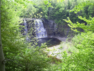
Today I headed up to Salmon River Falls in the Orwell(ish) area of Oswego County, New York. The falls had been an important fishing location for local Iroqouis natives before the settlement of the white men in central New York. Although, you wouldn't know it up in this area - there's hardly anyone here.

Recently the NY DEC has thrown some cash at the Salmon River Falls, and since it is situated on state land, they have built small trails and wooden stairs down to the top of the falls themsleves.

The falls are etched into 440+ MYA sandstones (that's Ordivician for non-geologers) and rise over 100' above the lower riverbed. The beds are mostly planar, with many ripple marks on the top layers, which are heavily jointed.

I appologise for the brief geology session, but this was more of a reconaissance mission than an in-depth study. However, if you're curious as to the formation of the falls - so am I. The river system, not a very powerful one, cuts deep into the sandstone without much explanation. My guess is that this was formed subglacially, mainly due to my previous studies on tunnel valleys along with the presence of striations and potholes, but I've truly never seen anything produce a channel quite like this one.

Now for pictures!
With my girl Lily atop the Falls.

The Salmon River leading towards the Falls.
Some glacially "punk'd" asymmetrical ripples.

The Falls themselves.
...And cliffs on the northside of the channel.

Tuesday, May 5, 2009

Soil Nails

Pretty interesting story out of America's west coast here. The Colorado-based company, Landslide Solution Inc., has created this tremendous air compressor\nail gun to drive "nails" into unstable hillsides, effectively creating a block of soil on the hillslope, rather than building an unstable retaining wall or letting nature takes it course. Heads up to Dave's Landslide Blog for this one.

See the video.

Saturday, May 2, 2009

Fun Fact


Had to share this with everyone. It's an old paper, and I'm no professional ecologist, but Mackie, et. al. 1989 has this to say:

"Crayfish could have a significant impact on the densities of 1 to 5 mm long zebra mussels. An adult crayfish consumes an average of nearly 105 zebra mussels every day, or about 6000 mussels in a season."

Just a thought, NYSDEC.


Friday, May 1, 2009

Lesson and Photo of the Day

Mmm. Floods. I don't know what it is about them, but I love floods. We become so accustomed to seeing water in certain places, and when said water breaches it's banks it creates, to me anyways, a whole new world.

Floods like the one we see in the picture are generally "absorbed" by riparian zone ecosystems which are generally recognized as the wooded borders of perennial streams. Riparian zones accept some excess sediment load from streams, absorb nutrients such as phosphorus and nitrogen (instead of depositing them in estuarine environments and creating hypoxic environments) and create beautiful woodland habitat.

This particular flood occurred in Spring 2009, in Blossvale, NY. Spring meltwater from the Tug Hill Plateau (which received over 9' of snow in some places) rapidly makes it's way downstream to Oneida Lake (after being intercepted by the NYS Barge Canal).

Tuesday, April 28, 2009

Watauga Falls

In the Fall of 2007, we went out to this outcrop, or waterfall in Delaware County, rather proximal to the town of Delhi. I don't remember the exact stratigraphic location of the falls themselves, but I do recall an abundance of excellent sedimentary structures, including ripple marks, as well as cross stratification in multiple directions.

The bad news: after about 1 hour we realized there was a Delaware Co. police vehicle parked behind our van. Needless to say, we were out of there way too soon, but there long enough to get some nice shots of the falls.

On a side note, this was the top terrace of a two-fall system. The second terrace was much larger, at least 4x as wide, and over 100' vertical drop. However, the lower falls were not accessible from out position.

Wednesday, April 22, 2009

Weekend Water Quality Testing of Upper Susquehanna Watershed


Watershed Management (Geology 384) headed down the Susquehanna River to check on Nitrogen loads. The main idea was to check into wether the Susquehanna River was contributing the most Nitrogen load, or if the Unadilla and Chenango Rivers were contributing more. The results were quite typical, and as of right now, the Susquehanna exiting the state of New York falls within the nitrogen alottment.

Tuesday, April 21, 2009

Maine USGS Makes the US a little more Green


Just got this email from Augusta, Maine's Water Science Center and they really impressed me with this one. They have developed an instrument powered by both wind and solar energy to measure rain and snowfall in remote regions in Maine in order to predict the amount of spring meltwater to be expected in Maine's reservoirs. 

The whole article can be seen on the USGS website.


Friday, April 10, 2009

Welcome Notice


Welcome all ye water and rock loving geologers, naturalists, outdoor nerds and such to this elegant "blog" depicting life as a student of Earth (and sometimes Mars...) The purpose of this blog is to account for the natural beauty of our glorious planet, to observe and report the phenomenon that make this rock the best place in the universe to live; and much, much more.

The meaning behind the title dates back to the Spring of 2006, just before a joint field trip between a Mineralogy and Water Resources class at Oneonta State in Southern NY. Realizing something had been forgotten in his office, Dr. Devin Castendyk, from here on out to be referred to simply as Devin, was unlocking the door to his office, smiling and saying to himself, 

"Water and rocks...at the same time.." 

Those words, witnessed by myself and fellow undergrad hard-rock aficionado Mike DeVasto, come to life here in this humble post, which will concentrate on the local geology of wherever I find myself traveling to in my up-and-coming "real life". 

So enjoy it.You never know when it's all going to be gone. If you read this post, please realize your inside, and nothing you can ever get from this will ever account for a simple suprise moment in the wilderness, coming across a great mineral intrusion, or jumping a whitetail doe and faun from a quiet, seemingly quiet swamp. Read on, play on, live on.