Monday, October 18, 2010
Saturday, June 5, 2010
Mastery of the masters degree.
Recent Oneonta State Masters Program graduate Randall Willson was kind enough to send me a copy of his masters thesis and I decided (with his permission) to post it on here. The following excerpt is only the abstract to his 148 page thesis. Enjoy.
THE SEDIMENTOLOGY AND STRATIGRAPHY OF THE MANLIUS FORMATION (PŘÍDOLÍ?) AND ADJACENT UNITS: LOWER HELDERBERG GROUP, CENTRAL NEW YORK
The correlation of disconformities within western portions of the Helderberg outcrop belt in New York State has clarified stratigraphic relationships within the Manlius Formation and between the Manlius and adjacent units. Throughout the region, the Minelot Falls Unconformity marks the contact between the Thacher Member of the Manlius and the underlying Rondout Formation. However, at Skaneateles Falls, the Elmwood C Member of the Manlius rests on the Rondout Formation owing to onlap along the edge of the basin.
The Clockville discontinuity that marks the top of the Thacher Member and the base of the overlying Green Vedder Member (GVM), has been correlated westward, nearly to the limit of the outcrop belt. The GVM persists through this area, though it is significantly thinner than in eastern localities.
Tracing of the Olney Member has revealed a previously undocumented occurrence of branching stromatoporoids (Clavidictyon) in upper portions of the member, stratigraphically much lower than previous reports. Rather than grading imperceptibly into the Dayville Member, the Olney is unconformably (Terrace Mountain Unconformity) overlain by the Dayville, a relationship that is clearly displayed in the town of Manlius. Therefore, strata previously assigned to the Olney east of Manlius, N.Y. are herein considered to be parts of the Dayville Member.
A subaerial unconformity preceded Elmwood deposition and progressively beveled older units westward. The “Manlius tongue,” mapped by Rickard (1962), is not a simple progradation of Manlius strata into the surrounding Coeymans facies, but is a result of the misinterpretation of the uppermost Dayville strata as “undifferentiated Elmwood.” The top of the Elmwood/base of the Clark Reservation Member is also unconformable. Trypanites-bored hardgrounds throughout the Clark Reservation suggest significant stratigraphic condensation within this unit. The notion of a “Manlius tongue” is further compromised by recognition of a second subaerial unconformity that preceded deposition of the Jamesville Member. Traced eastward, this unconformity truncates the Clark Reservation, the Elmwood and then the uppermost portion of the Dayville Member before it is cut by the descending Howe Cave Unconformity near Cherry Valley. These stratigraphic relationships further emphasize the need to reassign the Dayville Member from the Coeymans Formation to the Manlius Formation as suggested by Ebert and Matteson (2003).
The GVM (informal, upper thin-bedded Thacher) of the Manlius Fm. is present within most sections studied, and is characterized by hummocky cross-stratified wackestones and packstones interbedded with mudstones and calcareous shales. Beds of the GVM typically display flat basal contacts overlain by planar to cross-laminae and less commonly rippled caps, a sequence typical of tempestitic shelf deposits. Firmgrounds to hardgrounds developed on upper surfaces of many beds (mm to few cm) are strewn with ostracods, brachiopods, encrusting bryozoans and horizontal burrows of Planolites indicative of post-storm recolonization. Equant spar-filled fractures (mudcracks of Laporte (1969), and others) are common along hardground horizons in mudstone-wackestone beds and are interpreted as subaqueous in origin. Interbedded calcareous shales and mudstones exhibit ramifications of Medusaegraptus (a dacycladacean alga), vascular plant debris, soft tissues of annelids, microbial mats, and rare tentaculites.
Thicknesses of the GVM at Oriskany Falls and Munnsville indicate maximum basinal subsidence in this area during deposition. At western outcrops, hummocks are much broader (> 1m) than their counterparts to the east. Shallower facies to the east are demonstrated by hummocks with much shorter wavelengths, sometimes displaying a nodular appearance associated with large ripple/dune forms. Correlations between outcrops displaying the GVM indicate an eastward shallowing from Oriskany Falls to Schoharie. To the west of Clockville, upper beds of the GVM are truncated by the overlying Olney Member of the Manlius Formation via the Terrace Mountain Unconformity. The presence of this sediment-starved, storm-dominated shelf setting in the presumed peritidal Manlius Formation raises new questions regarding the evolution of the Appalachian Basin during Helderbergian time.
Tuesday, May 18, 2010
Footage of Eyjafjallajökull
...I first saw this video through GeoTripper, who got it from Little Red Tent and Americablog. Video by Sean Stiegemeir.
Iceland, Eyjafjallajökull - May 1st and 2nd, 2010 from Sean Stiegemeier on Vimeo.
Sunday, May 9, 2010
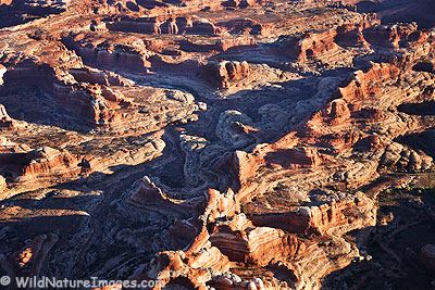
New Photos on Flickr...of Zion

Zion is my favorite natural place on our planet. It is simply indescribable as anything but.
Sadly, this past summer I was only able to spend two nights in the majesty of this land. I took a few photos, but you absolutely have to experience Zion for yourself.
Go here to book a trip. It is worth your time.
Or, go here, to check out my Flickr snaps of Zion.
Wednesday, May 5, 2010
New Group on Facebook
I've noticed many blogs have recently created fan pages on Facebook. I've thought about doing this myself, but have decided against it.
Rather, I have just created a new group for those of you who appreciate maps.
Maps, maps, maps.
I have created a group, simply entitled "Maps."
Geologic Maps:

Political Maps:

Digital Maps:

All Kinds of Maps.
Please join, and invite your chums. Also, if you frequent this blog, please become a follower, so I can get a better idea of the interests of the readers, and write further on what other would enjoy reading.
Thanks.
Also, we may have a new author soon. The suspense thickens.
Tuesday, April 27, 2010
Finally starting to notice?
This morning I fired up my email account to see a new USGS Release waiting for me.
"USGS To Award $4 Million in Earthquake Research Grants"
Hmm. Maybe it's about time. Inhabitants of our planet are starting to take notice. In this short calendar year, we have seen quite a few devestating seismic events hitting populated area and regions proximal to high population centres. Along with the eruption of Eyjafjallajökull, the science of geology is becoming more and more a part of everyone's lives.
Take a look at your TV guide when you get a chance. Over the past few years, National Geographic, Discovery and Science Channel have produced many a show pertaining to geologic phenomena, but only now are we beginning to see repeated shows, marathons, and even geologists themselves narrating said programs.
Of particular commonality, I believe I have seen Iain Stewart's How The Earth Was Made series, and volcanologist Guy de Saint Cyr, host of On The Volcanoes of the World. For the record, I recommend both of these programs. On The Volcanoes..., however, is much more adventure-themed, rather than teaching-themed, but you may be able to see some things you never have before.
It is a bit troubling that tragedies such as Haiti, Chile, and most recently the Qinghai quake of China; are what it takes for seismic hazards to be noticed.
Monday, April 26, 2010
Shameless attempt to stay active in the geo-community

Since I have a meager full time job an hour away, I dont have time to go hunting for fossils like rockmaster Ruuy does (uber jealousy). I sometimes work 11 hours a day, often six days straight. On my days off, I coach a youth soccer club (crossing fingers for a 8-0-0 season). Anyways, I read a book awhile ago written by Jack Horner, Professor of Paleontology at Montana State University and from the sounds of it, God 2.0. The title of the book is "How to build a dinosaur." I suggest going out and buying this book. Its yummy.
Horner and his author-sidekick James Gorman, after explaining the idea behind the book, describe in detail the vast paleontological digs they took part in. The Hell Creek formation in Montana is a hotbed for dinosaur fossils (jealousy meter rising again). Later in the book, Horner begins to propose his hypothesis on hatching a modern day dinosaur using chicken DNA. Horner compiles the physical similarities between chickens and ancient dinosaurs and further supplements it with similar traits in their chemical and genetic makeups.
I'll leave the actual book review to Good Books and Wine, but Horner does infuse a good amount of humor into a potentially dry topic. He also dumbs down the writing so non-rockology readers can understand the concept. It was a good read.

Thursday, April 22, 2010
They're not Seahorses, They're Eurypterids
With the coming of a new season, one which does not bury the Central New York strata in many feet of snow, is the gradual opening of an unofficial hunting season.
The snow disappears, some glaring ball of fire in the sky once again shows it's face. The ground dries out and pack boots are not required for simple tasks such as walking dogs or getting the mail.
Colorful birds show up or molt from earth toned ones, singing the hunter into the woods as he finally - after months of researching, planning, readying the weapons and of course - dreaming of the kill.
This time has approached in central New York. The season is open.
It's time to hunt some fossils.
ON Tuesday earlier on this week, fellow dead-animals-in-rock enthusiast Randall and myself decided to meet up in Mohawk, NY to start a journey through the Silurian and Devonian boundary rocks of New York's Mohawk Valley. Stops were planned in a total of three counties (Herkimer, Oneida and Madison) known for sedimentary rocks of the middle Paleozoic seas.
Starting near Mohawk, NY; our first stop were Dayville Member carbonates...which are pretty much in the middle of nowhere, near the town of Getman Corners.
 On top you can see some the much more planar-bedded Dayville. Member. We're still in the (upper) Devonian at this point.
 Here's a huge tabulate coral. Huge by my standards, anyways. This guy is the biggest I have found. The entire top layer you see in the first image is composed, almost entirely, of rocks similar to this. Float blocks at the bottom of the slope (which you may also view in the first image) are composed entirely of tabulates.
We then decided to do a short little drive in the nearby Spinnersville/Ilion area, in the vicinity of Lang's Quarry, famous for Eurypterids of the Fiddler's Green in great quantity and quality. As we neared Lang's however, there were up to six POSTED signs on each tree letting us know that we were not welcome. Maybe someday.
So we continued on to across the valley towards Litchfield. Near Jarusalem Hill there is a fine outcrop of Fiddler's Green in which Randall promised Eurypterid pieces. We got one better:
 Probably not complete enough to identify beyond it's genus, but still a great specimen in my opinion. I just managed to hit the rock in perfect spot, and this guy popped out. Randall also collecting an excellent carapace.
 This one was from a much bigger specimen, but as you can see, is quite incomplete. This came from a piece of float, so trying to find what could have been the carapace would be like, well, finding a Eurypterid carapace (not easy).
Then on to some of the Green Vedder Member (Devonian). Randall was here to collect some shales, and I was there to finally bite into my pulled pork sandwich I had packed five hours before. We did not stay long, as the aggregate company across the road had someone staked out watching us.
 We then visited the amazing Mosquito Point Outcrop in Munnsville(ish) which contained one of my favorite Devonian Formations, The Coeyman's Limestone.
 The darker rocks towards the top are Coeymans. The lighter, whitish rock, was composed almost entirely of these guys (On the right):
 Tabulata abound!
The Rugosa sp. to the left is from the Coeymans.
Typical Coeymans:
 Two nice fat gastropods. Gastropods, though incredibly interested to me, are not my specialty. I wish I could at least place them in a Genus, but alas, cannot at this time.
We ended at Stockbridge Falls, over the hill and across the valley from The Mosquito Point outcrop.
 The area was littered with Onondaga Limestone (Onondaga Formation), which in this area is likely to overlay either Coeymans or Kalkberg Limestone of the Helderberg Group of the Early Devonian.
Saturday, April 17, 2010
Eyjafjallajokull Jokulhlaup Video!
(Look at all those vowels...)
A heads up i credited to Dave's Landslide Blog for posting this video earlier this morning (probably afternoon in Durham by now) but needless to say, this is a must see - not only for geologists and rock hounds alike, but for everyone. I mean everyone.
I will write up a post shortly on jokulhlaups - their causes, mechanisms and past events. Truly amazing phenomena. Stay tuned.
Tuesday, April 13, 2010
Dinosaurs on Baseball Cards
I wanted to brew up a quick post on the intermingling of two of my favorite past times.
Dinosaurs and Baseball Cards.
Recently, card companies have been exhuming the remains of baseball cards past. This includes resurrecting themes which vanished hastily when baseball cards first died in popularity. This was almost 100 years ago at this point, so I don't believe anyone who reads this will know what I'm talking about. Old designs are intentionally being reused, and with this theme, old idea. Back when card still came with tobacco, card would also come printed with pictures of boxers, flags of nations far away, historical figures, and of course, dinosaurs.
But I know many people love to collect dinosaur related things, and these "things" are my favorite.
Right now, I only have two dinosaur cards, and I will post them here.
The first, is Taurosaurus:
 As you can see, Upper Deck, the company which makes these, did a hell of a job. They are actually "mini" in size, roughly 1/2 to 1/3 the size of a normal card. You can count on getting one "Natural History" card in every fourth pack, so they're not very easy to come by for a modest collector.
From the back of the card:
"The Taurosaurus, meaning "Wide Perforated Lizard," lived during the Late Cretaceous Period (About 70 Million Years Ago.) With a length of 25 feet and a weight of up to six tons, the Taurosaurus had two long horns over it's eyes."
Granted, you cannot fit much on the back of one of these cards, so understandably, the descriptions are brief.
Now for my favorite.
 This one is from 2008-2009 set, out for almost a year now. I looooves me some Stegos. They may have spent a little more time on this set, or maybe they're just better for having much more iconic dinosaurs, but here is the description for this one:
"An armored herbivore of the late Jurassic period, the Stegosaurus was distinguished by the dual rows of pointed, bony plates that ran along it's back as well as the long, dangerous spikes that rose from it's tail.
Roughyl 30 feet long, 15 feet tall and six tons in weight, the Stegosaurus' brain was only about the size of a walnut."
Way to dis the beast at the end, Upper Deck. Still, I'd rather be a Stegosaurus than anything that ever lived, except for maybe Eurypterus remipes, Amargasaurus cazaui or Canis familiaris.
If you're interested in finding some of these for yourself, hit up eBay and search for "UD Champs National History" or "2010 Allen Ginter Monsters of the Mesozoic" later this summer.
Friday, April 9, 2010
Dinosaurs and Volcanoes
I came across this great post today at Love in the Time of Chasmosaurs. If you have not discovered it yet, I suggest you check it out. And if you can, join and submit some Vintage Dinosaur Art to the Flickr Group!
Here's the first one I came across, and I have to say it's quite perfect:
 This is from page 403 of Prothero & Dott Jr.'s Evolution of the Earth Textbook. If I could scan the cover, featuring one of the most amazing Amarghasaurus art of all time, I'd get that in there, too.
Wednesday, April 7, 2010
Disappearing Stream Video
So I'll have to do some more snooping around with this stream. It seems to be getting bigger every year, and I am yet to figure out exactly where this particular stream is discharging into the river (if it is, even).
Saturday, April 3, 2010
Redundant, But About Time
At risk of sounding redundant, I'd like to reiterate Callan Bentley's tweet yesterday of "About time..." in regards to the Obama administration FINALLY putting an end to this environmental catastrophe.

Is Glen Canyon Dam next? Probably not, but I can dream.
Photo taken from Coal is Dirty.
Is Glen Canyon Dam next? Probably not, but I can dream.
Photo taken from Coal is Dirty.
Tuesday, March 30, 2010
Science Caught in the Act - Dam Break
I threw this video together earlier today. This is another of a series of videos from "The Station", a first order drainage in which I conduct fluvial experiments. In this case I have released a plug from underneath a dam (fallen log across the stream) and record what happens with the stream afterward.
Enjoy.
Enjoy.
Friday, March 26, 2010
Hey, Look - Fossil Leaves
 So this blog has had a steady diet of paleo lately, and, well, I'm okay with that. My initial thought in the formulation of this post was to pick a random image from the Western Regional Field Course this past summer and make a short little post on it, to keep the readers (all seven!) on their toes.
The above image is from Mesa Verde National Park in the southwestern corner of the magnificently geological state of Colorado. In reality, all states are amazing geologically, even Nebraska (you can't see the Ogalalla, but they still have a Fluvial gem in the Platte).
Mesa Verde may be most well known for the excellent preservation of Anasazi cliff dwellings, but the geology of this park is truly amazing. Perhaps Aucoin will get into the geology-archaeology intertwining in a future post here.
Back to the leaf fossils. The fossil leaves fall into the appropriately names Mesa Verde Group, a late Cretaceous, cliff-forming brown and gray layered sandstones. The importance of the leaf fossils were integral in determining the depositional environment of the Mesa Verde Group.
With the fossil leaves of the Mesa Verde Group, paleontologists or fossil seekers may find other wood debris and a huge variety of plant species, but rarely, if ever, marine fossils. The fossils are so well preserved in some places that the cuticles of the leaves can be peeled off of the rock when freshly split (Raynolds, 2007).
As of Raynolds, 2007, over 100+ seperate leaf species have been identified in late Cretaceous rocks in Colorado. Further investigation led to identifying many of these leaves as drip-tip bearing angiosperms. Drip tipped leaves are common on today's Earth in humid, high rainfall tropical rainforests. the drip-tips relieve the plant of leftover runoff moisture, which can lead to mold and disease in plants.
With the presence of these plant fossils, and the lack of marine specimens, coupled with the grain size and distal relationships (source and sink) of the sediments, the Mesa Verde Group has been labeled a lagoonal type deposit.
Sources:
Raynolds, Robert G.; Johnson, Kirk M.; Ellis, Beth; Dechesne, Marieke; Miller, Ian M. 2007. Earth History Along Colorado's Front Range: Salvaging geologic data in the suburbs and sharing it with citizens. Denver Museum of Nature & Science, 2001 Colorado Boulevard, Denver, Colorado 80205.
Johnson, K.R., and Ellis, B., 2002. A Tropical Rainforest in Colorado 1.4 Millions Years after the Cretaceous-Tertiary Boundary: Science, v. 296, p. 2379-2383.
Note: The above sources do not refer to leaves of the Mesa Verde Group. The units are similar at Mesa Verde to those of the Castle Rock Flora site, and this was the reason I used these papers. That, and, they were the only source I am aware of.
Thursday, March 25, 2010
Who wants to help on a little project?
I just finished reading The Monkey Wrench Gang by Edward Abbey. Short of writing a full review at this time, I'll just say this - it was amazing, and something every nature fan, natural scientist, angered youth or disgruntled conservationist should read. I mean it. I'll even lend out my own copy. Absolutely mandatory read.
On to the plan. No, I do not plan on blowing up the Glen Canyon National Sewage Lagoon Dam. What I'd like to do is grab a few maps of Arizona and of course, Utah; and retrace George Washington Hayduke's journey through the lands. Being somewhat familiar with the country, I did so already while reading the book. I got through most of Southern Utah without a problem, but will need to consult some maps to complete it all.
Anyone else interested?
Wednesday, March 24, 2010
Getting Along With Geologic Time #1 - The Silurian

Graptolite Monograptus tomasii and early plant Baragwanathia longifolia
in Silurian silicics of Australia. Image from Geological Society of Australia.
This series of posts will not be (geo)chronological. If it were, it would be no fun. Plus, I know a good quantity of Oneonta Staters that wouldn't log onto this blog for months if they knew the evil, evil Devonian was coming along.
So here we go, Silurian Stylee.
The Beginning
As with all geologic periods, the beginning of the Silurian is characterized by new life after a substantial loss of biotas worldwide. In the case of the Ordovician/Silurian (OS) boundary, there was a mass extinction of 60% of earth's biotas at this time, mainly devastating marine shelf-life. The mass extinction(s) were second in magnitude of deceased marine species, only to pale in comparisson to the horrible events circa 249 MYA. Interestingly, the OS mass extinction is classified by two events, one at approximately 442 MYA another a short 1 MY later. During this time, Gondwanda was drifting into the higher southern latitudes, eventually passing near (possibly completely over) the Southern Pole. This process led to a cooling of the land masses, and likely a global cooling to boot. This cooling, of course, led to extensive glaciation of the Ordivician world. Thus, the world's waters became trapped within extensive ice masses, and sea level dropped. With the corresponding drop in sea level, shallow marine life suffered due to extensive habitat loss. Bryozoans, brachiopods, bivalves and echinoderms suffered the greatest.
The Origins
Silurian refers to a Welsh tribe, the Silures. In 1835, the term "Silurian" was coined by none other than British geologist Roderick Murchison, in a series of events which led to the initial geologic time scales. In a joint paper with fellow Adam Sedgwick, On the Silurian and Cambrian Systems, Exhibiting the order in which the Older Sedimentary Strata Succeed each other in England and Wales; the birth of the geologic time scale, as we know it. Sort of. The partnership of Sedgwick and Murchison would later dissolve over disagreements between the end and beginning of said periods. However, Charles Lapworth later defined a new period in between, the Ordovician, resolving the conflict.
The Epochs

(Europe, North American Equivalent(s))
Llandovery, Alexandrian (443-428 MYA)
Wenlock, Lockportian/Tonawandian (428-422 MYA)
- Oldest known Tracheophytes appear
Pridoli (418-416 MYA)
- Named for the town of Pridoli in the Czech Republic, where excellent exposures of the SD (Silurian/Devonian) occur

Image courtesy Dr. Ron Blakey, Northern Arizona University
As stated earlier, the Silurian geography can be characterized by a slow, southernly drift of supercontinent Gondwanda. Aside from Gondwanda, there were a number of other land masses and cratons drifting towards the equator. These multiple land masses were in the business of colliding around the equator, leading to the Caledonian Orogeny. During this time, land masses of the current New York State, Greendland and Norway were colliding in order to form a second supercontinent, Euramerica.
If you take a look at the image above, generously shared via Wikipedia and UNA's website by Dr. Ron Blakey; you'll notice a massive ocean dominating the northern hemisphere. This ocean, known as Panthalassa, was accompanied by the southern oceans of Proto-Tethy and Paleo-Tethys, which later evolved into, you guessed it; the Tethys Ocean. Also present was the Rheic Ocean, a seaway of the Iapetus.
If you take a look at the image above, generously shared via Wikipedia and UNA's website by Dr. Ron Blakey; you'll notice a massive ocean dominating the northern hemisphere. This ocean, known as Panthalassa, was accompanied by the southern oceans of Proto-Tethy and Paleo-Tethys, which later evolved into, you guessed it; the Tethys Ocean. Also present was the Rheic Ocean, a seaway of the Iapetus.
Paleoclimate of the Silurian
After the Ordivician-Silurian cooling event, the Silurian period experienced a prolonged greenhouse phase. The glaciers which formed with Gondwanda's passing over the South Pole almost disappeared during the Silurian. With the rebound in Ordovician sea levels, the Silurian saw a return to general climate normalcy, in contrast to the erratic conditions of the Cambrian and Ordovician.
Multiple stratas of coquinas (sedimentary rock composed of broken shell fragments) characterize many units of Silurian formations. These conquinas are evident that violent storms were common in the Silurian. Plentiful, violent storms are typical of time periods in which shallow, easily warmed sea surfaces.

End Silurian Mass Extinction Event(s)
The end Silurian extinction, in comparison to others, has been rather neglected in terms of research and understanding. Rumblings has produced trite reasoning such as "probably caused by climate change..." and other vague scenarios.
The widely accepted Lau Event at 420 MYA, the final of three extinction events ending the Silurian; is viewed as a peak in sigma 13 C (blogger does not allow for greek lettering and sub/post scripts) levels. However, the Lau Event, characterized as a massive conodont extinction events, lags behind the disappearance of index fossils by at least one million years. Building upon this event, some paleoclimatologists have theorized another glaciation event as a possible climatic situation contributing to the extinctions.
So what's so great about the Silurian?
So we've reviewed the main concepts of the Silurian. No much ice (lame), a good amount of warm-weather storms (very awesome) and relatively quiet orogenies (Caledonian Range is all we really have to show for it).
What really sticks out about the Silurian is the organisms. The Silurian period is home to the first tracheophytes and land-dwelling vascular plants.
 Cooksonia, above, and Baragwanathia, shown in the first image on this page; are some early examples of these early vascular plants. Vascular plants are those which are able to carry food through lignified tissue, and are exclusive to land. Modern examples of vascular plants include ferns, clubmosses, flowering plants, conifers and gymnosperms.
We have the Silurian to thank for these precious lifeforms today.
While the Silurian was an integral time for the plant life of planet Earth, life in this time was dominated by the oceans.
Fishes underwent important changes. The first fish with jaws evolved, and those without jaws diversified.
Some of the first animals to take to land, various centipedes and scorpions, did so during the Silurian.
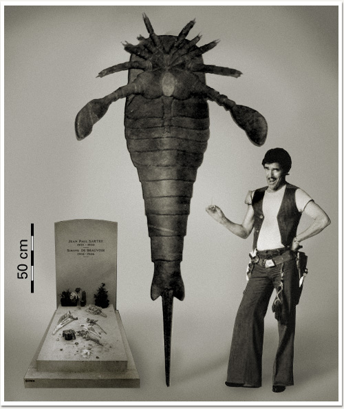
And there's these:
 Mixopterus multispinosus
One particular Silurian eurypterid is known as one of the largest arthropods ever know (and by known, of course, we mean fossilized), Pterygotus. Pterygotus was capable of reaching an enourmous 2.3 m (that's about 7', you imperialists.) However, as is so common in the fossil record, biggest is certainly not the best. Pterygotus died out by the middle Devonian. Four species of Pterygotus existed, with P. anglicus being the type species. The genus was first described by none other than the legendary Louis Agassiz in 1839. (Go Switzerland!)
And, for a little joke:
 Did you know elephants diversified in the Silurian? Neither did I!
Stay tuned for more Getting Along with Geologic Time.
Sources:
Don't be completely discouraged by Wikipedia. Most of the time, the articles are written by legitimate scientists with proper sources. I always check the sources before using the information.
The Paleontology Portal
Wikipedia - The Silurian
Wikipedia - Vascular Plants
Go baseflow go!
Due to the current state of the economy and the current job, I do not have the funds or time to conduct elaborate experiments at the time being. So for now, try to enjoy a series of extremely amateur mini experiments!
I was reading the paper the other day and saw an article stating there was a possibility of some flooding. I was able to scrap up some petty cash (no joke) and purchased a cheap rain gauge. I was able to rig it up to the door of the dog cage in my backyard like so:


I was reading the paper the other day and saw an article stating there was a possibility of some flooding. I was able to scrap up some petty cash (no joke) and purchased a cheap rain gauge. I was able to rig it up to the door of the dog cage in my backyard like so:
After returning 24 hours later, it yielded ~4.4cm of rainfall for the previous night.

The opening to the gauge has a total 2.54cm(sq) surface area for a total of 4.4cm of rainfall per 2.54cm of surface area. This amount of rainfall for a 24 hour window in a much larger space plus baseflow from higher elevations and still melting snow would definitely cause some amounts of flooding....alike so:


Tuesday, March 23, 2010
Things to get Downright Fluvial About
After a few days, I went through the videos of the drainage experiments, and here they are:
**As of 3/23/2010 17:18, Two of the three videos have not yet been processed by YouTube. Please be patient, they'll be up soon.
#1 - Quick Mass Movement
#2 - Mass Movement and Damming
#3 - Earth Dam Break + Knickpoint Migration
I left out the best part. I ripped some leaves away from around a groundwater seep and watched a beautiful drainage pattern form. However, as soon as I calmed down from the beauty of it all, I clicked the camera on to get a blinking battery icon.
These things happen. I was able to snap a good amount of photographs of it though, and they should be up within a few days.
Also, look forward to this blog linking up with my flickr account within the next few days.
Sunday, March 21, 2010
The New Directions of Water and Rocks
Since my return from the NE/SE GSA conference this past week, it has been increasingly difficult to rage on over topics typical of this blog. I wanted to take this blog slow, waiting until a solid faction of followers was present, and grow like like to CO2 levels in our atmosphere (zing!). This hasn't been the case. Debuting in May 2009, Water n Rocks has only totaled 4 followers. Two of which are authors of this blog, and two are emotionally involved with authors.
It isn't about the followers, and due to adding Water and Rocks to Facebook traffic has been on the rise. Mostly from a small mountain town in Southern NY, and some image searches which have led viewers here ("People write about rocks and water?!").
Needless to say, this blog is not a diary. I started it in order to open peoples eyes to the wonders of out natural world. Yes, with emphasis on geology, geomorphology and hydroscience; but still as a source of pictures for people who just want to discover new natural phenomena in their own backyard.
It was quite embarrassing on the art of this blog to be outright rejected by a very populat blogroll, Nature Blog Network. I will not link to this site as I do not wish to start a word war with these folks, rather I just want to pass on this new life anecdote I have learned from this experience.
Don't take anything too seriously. I was pretty upset with the rejection. "We feel your blog does not match our interests...(paraphrased)" was downright insulting at the moment I read the terse email. Why would a blogroll intended to bring people into their community reject someone searching for a community to belong to? It doesn't make much sense. But this is not the point of this post. The point of this post is more of a State of the Blog address.
So without further adieu, here is what you have to expect in the next epoch (see what I did there?) or Water and Rocks...at the Same Time.
Field Research
I am currently conducting makeshift experiments in first-order drainages in hope of finding insight into catastrophic flooding - think Lake Missoula floods, the "biblical" flood, etc. This is more intended for educational purposes rather than hard science. Quick and Dirty, if you will.
Textbook Diving
Anyone who knows how I function can recall and excessive amount of textbooks, from amazing to awful; on a bowed down shelf in my room. From time to time I will be diving into these textbooks, finding diagrams and visual aides to help clarify geologic and hydrologic concepts - both quantitative and qualitatively.
Pictures!
The photos from the Western Trip of 2009 do exist, I swear. I was doing a photoblog type presentation of this trip, and may continue to, but not in the frequency I was. I burned myself out with massive posts on locations. Trying to fit a week of the Grand Canyon into one post is...well, impossible.
Philosophy
Just kidding. I do not believe in philosophy (dodges poorly thrown bricks). Instead, I plan to question whatever I feel like, from other scientists' research to my own (clay varves in CNY?! Bullshit!)
Themed, Seriesed Posts
And making up new words, like seriesed. Along with the textbook dives, I also plan on multiple types of posts with a common title or theme. One of which will be glimpses into geologic history. Most common, I will go back to the Plesitocene and Siluirian. Because they're awweeesommmme. Deal with it.
 And more. I don't know what, yet, but be ready for anything. Also, I am looking to start a new blog in which the ONLY topic will be geology, hydrology and biological field trips (this includes paleo-goodies).
And as always, please comment, leave positive and negative feedback, and if you are interfested in becoming an author at this blog, please let me know.
Wednesday, March 17, 2010
Who knows where ideas come from. They just appear.
Time to think about whatever for the first time in almost a week.
The rain killed all the snow, so the field season is back and full of piss and vinegar.
I exhumed the bookface after years of dormancy. Three years dead. Science is a hell of a drug.
I played in a first order drainage for two hours today. I diverted flow. I built dams out of clay, pebbles/cobbled and debris. I watched sediment bars build, surface, drown, erode and grow up to be sediment is another bar downstream.
I took videos of a bank collapse, bar formation and upwelling.
Three packages came in the mail. Oh, happy day.
A bill came in the mail for loans. Oh, terrible day. (It's okay, they'll be dormant again for two years.
Bookface has transformed into a terrifying ad machine.
I'm still waiting on my Buffalo email account, to detach myself (slightly) from the substance abuse capital of college, Oneonta State.*
According to a talk at GSA by Callan Bently of Mountain Beltway, GeoBlogging is on the rise. Maybe I'll shout at him to check out this site and the winners over at Second Floor Science. Good kids over there.
Something you may not hear so much: How can I delete friends from bookface?
I have a dream. That dream is to build a house. Within this house, a staircase. Within this staircase, in ascending order, slabs of the Grand Staircase.

I can ride my bike with no handelbars, no handlebars, no handlebars.
I have so much to do with my life. I just want to play in water.
Dear Baltimore, you embarrassed yourself with your so-called Buffalo Chicken sandwich. Stick to blue crab and lake trout.
This is the most amazing graph of water usage I have ever seen. During the USA/Canada gold medal hockey match:

I have another new blog idea. Geology field trips only. I would be looking for multiple contributors, world wide.
*Disclaimer: Most of the students at Oneonta State are good human beings. Some casually drink and know how to control themselves. Others, not so much.
Thursday, March 11, 2010
Huh?..Wha?...Oh. Hello Spring.

Like bears waking from hibernation, us non-glacial geologists awake from the winter coma ready for some hot, outdoorsy geology action. I personally am looking forward to locating and dusting off all the research gear and heading out into some remote creek or stream but any geologic expedition would not be overlooked. Keep checking in on any fun and wacky adventures we all get into this spring and summer!
Monday, February 22, 2010
Oh, The Colors!

Looks like some nasty precipiation heading this way. I love watching storms like this slowly work their way west from Buffalo/Great Lakes to eventually lose power and totally disappoint me when they get to central NY...
Saturday, February 20, 2010
A Break in the Nothingness of Water n Rocks'... winter
 So in case you couldn't tell, I got into UB. I received a digital acceptance last week, but the final hard copy came in the mail today.
This is my second acceptance letter I've received overall (two out of three aint bad!) and both have come in a small envelope. This scared me originally in my Oneonta acceptance, as I was led to believe (via movies and such) that acceptance came in big beautiful 9"x11" manilla packets, or in boxes with hats, scarves and whatever college-labeled flair they can recruit you with. It's become obvious that either A) I'm just not that great a candidate, but just good enough to get in or; B) even colleges are cutting back on recruiting or persuasive techniques.
Anyways, I'll be in Buffalo this fall, unfortunately, without a project at this point. I got in on MA rather than MS basis, which isn't what I wanted, but will do for now. My plan is to get into an MS by semester #3, if not, I'll do the research my damned self. I've done it before.
_______________________________________________________
I've also extended an invitation to Joey from Oneonta/Port Jervis, NY to contribute to the blog. "Rock Doctor Aucoin" has created his own series of websites and such, so it seems like he's out for the time being. Tony is still here and looking for that magical glacier.
_______________________________________________________
My plans until grad school in August right now are jumbled. I'd love to get to GSA NE/SE in Baltimore, but right now it seems unlikely. I might start planning some summer camping/geology trips this summer, before asshole decides to shut down every park in the State. If this really goes through, I might spend my summer defended New Yorker's rights to access our beautiful land.
_______________________________________________________
Subscribe to:
Posts (Atom)


